Depletion of Arctic Ice Causes Biggest Change in National Geographic World Map Since Breakup of Soviet Union
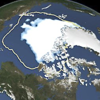
 The amount of summer sea ice in the Arctic on September 16, 2012, is represented at center in white, while the yellow line shows the 1979 to 2000 average for the same day (photo: U.S. National Snow and Ice Data Center)
It has been two decades since the cartographers at National Geographic had to make so many changes to its world map. In the early 1990s, the dissolution of the Soviet Union resulted in many lines being redrawn. This time, it was the retreat of the Arctic ice sheet that had mapmakers putting in overtime.
The 10th edition of National Geographic Atlas of the World, set to come out in September, will reflect what geographers say is a dramatic loss of “multiyear ice” (ice that survives for two summers).
National Geographic’s Juan José Valdés, a geographer, says the revised atlas reflects “the biggest visible change other than the breakup of the U.S.S.R.” This doesn’t come as a surprise to scientists who have recorded a 12% reduction in the ice sheet since the late 1970s.
Some experts apparently took exception to National Geographic’s choices in crafting the new map. Walt Meier, a research scientist at NASA Goddard Space Flight Center’s Cryospheric Sciences Lab, said it is misleading not to show the total area of existing ice at the end of summer because it leaves out ice that’s a year old or less.
“Personally, my thought is that it would be best to show the entire end-of-summer ice cover in white—which is how it generally would appear in a photo from above [without clouds]—with the multiyear area outlines or maybe offset in a different shade to highlight it. At the least, I think it would be good to put a clear line [to] denote the minimum extent,” Meier told National Geographic. The publication’s editors said they made the choice to keep the atlas from becoming too confusing for users.
Meier also suggested that the cartographers use an average of the ice cover, rather than only 2012, which was a bad year for ice cover.
-Noel Brinkerhoff
To Learn More:
Shrinking Arctic Ice Prompts Drastic Change in National Geographic Atlas (by Christine Dell’Amore, National Geographic)
“Unstoppable” Polar Ice Melt Portends Rising Oceans and Society in Crisis (by Noel Brinkerhoff, AllGov)
Russia’s First Shipment of Arctic Oil to Europe Arrives in Netherlands (by Noel Brinkerhoff, AllGov)
- Top Stories
- Unusual News
- Where is the Money Going?
- Controversies
- U.S. and the World
- Appointments and Resignations
- Latest News
- Trump Renames National Football League National Trump League
- Trump to Stop Deportations If…
- Trump Denounces World Series
- What If China Invaded the United States?
- Donald Trump Has a Mental Health Problem and It Has a Name


Comments