EPA Pinpoints Neighborhood with Highest Cancer Risk from Air Pollution
Friday, June 26, 2009
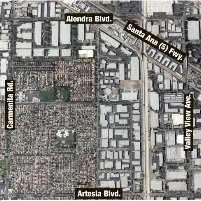
 (photo: Google Earth)
According to the U.S. Environmental Protection Agency, any community that averages less than 100 cases of cancer for every 1 million people is doing okay. Once the rate goes above a hundred, EPA considers the situation unacceptable. Which begs the question: What would EPA call the status of a neighborhood in Cerritos, CA, that has a cancer risk of 1,200? Alarming?
The area in question in Cerritos is an industrial zone bordered by Interstate 5 and Alondra and Artesia boulevards. EPA officials say poor air quality is behind the high risk of cancer in Cerritos, specifically because of concentrations of hydrazine, a colorless liquid used in rocket fuels and chemical manufacturing. Officials with the South Coast Air Quality Management District (AQMD) disputed EPA’s findings for Cerritos, claiming the local agency’s own testing showed Cerritos’ cancer rate and air pollution were not above average. Then again AQMD hasn’t tested for the presence of hydrazine, officials admitted.
AQMD has found, however, that cancer risks in Los Angeles and Riverside counties are far higher than what EPA claims. While federal environmental experts pegged the cancer rate to be between 75 and 100 for the two Southern California counties, AQMD estimated it is more like 1,200. And in Long Beach, downtown Los Angeles and Wilmington, the rate soared to as high as 3,200 cases per million.
-Noel Brinkerhoff
Study: Cerritos Neighborhood has Nation's Worst Air Quality (by Kelly Puente and Kristopher Hanson, Long Beach Press-Telegram)
Technology Transfer Network 2002 National-Scale Air Toxics Assessment (U.S. Environmental Protection Agency)
- Top Stories
- Unusual News
- Where is the Money Going?
- Controversies
- U.S. and the World
- Appointments and Resignations
- Latest News
- Trump Renames National Football League National Trump League
- Trump to Stop Deportations If…
- Trump Denounces World Series
- What If China Invaded the United States?
- Donald Trump Has a Mental Health Problem and It Has a Name


Comments