New Hollywood Fault Map Puts Projects and Buildings in a Quake Zone
 (graphic: California Geological Survey and LA Weekly)
L.A.’s grand plan to reshape Hollywood’s skyline with a string of dense developments through its heart now looks as shaky as the ground where construction is planned.
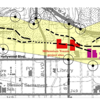
On Wednesday, state geologist Dave Parrish released recently-completed maps of fault lines in the city that seem to place the giant Millennium Hollywood skyscraper project, approved by the city in October, astride one of the dreaded dotted lines that mark an active earthquake fault. If that turns out to be the case, a state law that bans building on faults would be tough to get around.
Angry residents in the area who fear high density will cause myriad problems in their neighborhoods have already sued to stop Millennium. Similar concerns have been raised about two other projects, Blvd6200 and a nearby apartment complex, which both appear to lie within the fault zone.
The Hollywood map also shows a path 1,000 feet wide, along a 6-mile stretch roughly parallel to Hollywood Boulevard and the Sunset Strip, which overlays the contour of the fault. Any projects proposed for that zone, and there are a bunch, would be subject to intense seismic scrutiny. A second map, covering eastern L.A. County communities in the San Gabriel Valley, was also released.
A series of stories the past six months by the Los Angeles Times revealed that the state was woefully behind drawing promised maps of California’s earthquake faults and that the unofficial maps L.A. city planners and developers were using were out of date. Not only have projects been built on suspicious sites for years, new ones on the drawing board were moving forward with insufficient review of seismic factors.
The state law that forbid building on a fault and required seismic mitigation for buildings built in the zone around only applies when an official state map has been completed. Until now, that was not the case in Hollywood.
The state has mapped 5,000 miles of active faults, but still has 2,000 more miles to finish. California banned construction on fault lines after the 1971 Sylmar earthquake and official mapping of faults began. Over the years, the mapping depended to a large degree on work done by academia, which was then translated into official documents. Around 500 maps were drawn in the first two decades—and 20 during the next two, when funding for the ongoing project became dicey. Even after the Northridge quake in 1994 revealed a fault no one knew about, official mapping went nowhere.
According to the Times, the California Geological Survey (CGS) will run out of map money next June. Where six people used to do the mapping, only one will be toiling in the new year and that position will be gone soon.
The CGS is beginning work on mapping the Santa Monica fault on L.A. County’s west side and the western end of the Hollywood fault, but unless it receives increased funding, that work is problematic.
The public will have 90 days to comment on the maps and a finished map is expected to be released in July.
–Ken Broder
To Learn More:
New Hollywood Fault Map Curbs Development in Hollywood, WeHo, Los Feliz (by Gracie Zheng, LA Weekly)
Fault Maps Could Alter L.A. Development (by Tamara Audi, Wall Street Journal)
New State Fault Maps Show Higher Earthquake Risks in Hollywood (by Rong-Gong Lin II, Rosanna Xia and Doug Smith, Los Angeles Times)
Quake Threat Puts Hollywood Skyscraper Project on Hold, Raises Questions about Others (by Ken Broder, AllGov California)
2010 Fault Activity Map (California Department of Conservation)
- Top Stories
- Controversies
- Where is the Money Going?
- California and the Nation
- Appointments and Resignations
- Unusual News
- Latest News
- California Forbids U.S. Immigration Agents from Pretending to be Police
- California Lawmakers Urged to Strip “Self-Dealing” Tax Board of Its Duties
- Big Oil’s Grip on California
- Santa Cruz Police See Homeland Security Betrayal in Use of Gang Roundup as Cover for Immigration Raid
- Oil Companies Face Deadline to Stop Polluting California Groundwater


